Introduction to LeafletJS
- LeafletJS is a JavaScript library which allows for the creation of and interaction with web maps.
- It uses a simple API for building maps using Layers
- It allows for styling of the map layers using standard CSS and manipulation with JavaScript
Simple Map Example
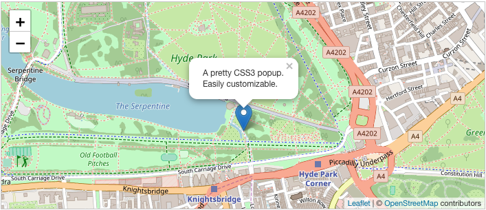
var map = L.map('map').setView([51.505, -0.09], 13);
L.tileLayer('https://{s}.tile.openstreetmap.org/{z}/{x}/{y}.png', {
attribution: '© <a href="https://www.openstreetmap.org/copyright">OpenStreetMap</a> contributors'
}).addTo(map);
L.marker([51.5, -0.09]).addTo(map)
.bindPopup('A pretty CSS3 popup.<br> Easily customizable.')
.openPopup();
Installation
Include the CSS and JavaScript in the Head of the HTML page
Add the CSS First
<link rel="stylesheet" href="https://unpkg.com/leaflet@1.3.1/dist/leaflet.css"/>
Then the JavaScript
Make sure you put this AFTER Leaflet's CSS
<script src="https://unpkg.com/leaflet@1.3.1/dist/leaflet.js"></script>
Then create the map container
<div id="mapid"></div>
Then use CSS to create a height for the container
#mapid {
  height: 400px;
}
Using a Basemap
- Basemaps are composed of Tiles that show:
- You add the basemap to the map container
Mapbox Basemap Example
L.tileLayer('https://server.arcgisonline.com/ArcGIS/rest/services/World_Imagery/MapServer/tile/{z}/{y}/{x}',
  {
    attribution: 'Tiles © Esri — Source: Esri, i-cubed, USDA, USGS, AEX, GeoEye, Getmapping, Aerogrid, IGN, IGP, UPR-EGP, and the GIS User Community'
  }).addTo(mymap);
Basemap providers for LeafletJS
https://leaflet-extras.github.io/leaflet-providers/preview/
What the L ?
-
L is the global LeafletJS function.
- You can access all the objects and functions within LeafletJS from L
- There is extensive documentation:
L.map('map').setView([51.505, -0.09], 13)
Adding Markers
- Markers add a point to the map
- The text of a marker can be set using a string of HTML
let marker = L.marker([51.5, -0.09]).addTo(mymap);
marker.bindPopup("<b>Hello world!</b><br>I am a popup.").openPopup();
Removing Markers
- Markers can be removed by calling
remove() on the marker object
let marker = L.marker([51.5, -0.09]).addTo(mymap);
marker.remove();
Adding Polygons
- Polygons are arbitrarily shaped regions of the map
- They can be created and added to the map
let polygon = L.polygon([
      [51.509, -0.08],
      [51.503, -0.06],
      [51.51, -0.047],
    ], { color: 'red'}).addTo(mymap);

// delete the polygon later
polygon.remove()
Other Shapes
Several other map shapes exist:
- Path
- Polyline
- Polygon
- Rectangle
- Circle
- CircleMarker
https://leafletjs.com/reference-1.3.0.html
GeoJSON
- GeoJSON is JSON with specific properties for maps
- It is a simple means to communicate location data
- Alternative to .shp files and the variants; .shx, .prj, .dbf, ect...
{
  "type": "Feature",
  "properties": {
    "name": "My Layer",
    "latitude": 44.0886,
    "longitude": -72.7317
  },
  "geometry": {
    "type": "Polygon",
    "coordinates": [
      [
        [-73.35218221090553, 45.00541896831666],
        [-73.18201496808604, 45.00562770855899],
        [-72.76588580182134, 45.00611110701493],
        [-72.34976762188519, 45.006605491799434],
        ...
        ...
      ]
  }
}
let someLayer = L.geoJSON(geoJsonData);
someLayer.addTo(mymap);
Point-within-polygon
- Libraries which exists to check containment of a point in a polygon
https://github.com/mapbox/leaflet-pip
Installation
<script src="https://unpkg.com/@mapbox/leaflet-pip@latest/leaflet-pip.js"></script>
Usage
let layer = L.geoJson(statesData);
let results = leafletPip.pointInLayer([-88, 38], layer);
/